Your cart is empty.


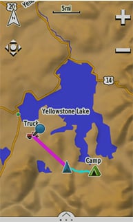
Combining map-guided trail navigation with two-way radio communication, the Rino 750 and 755t handhelds bring a whole new level of confidence to your outdoor adventures. Both models feature a unique position reporting capability that lets you send your exact location to other Rino users so they can see it on their map displays.
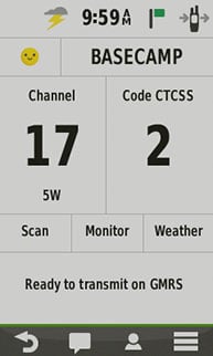
Both Rino 750 and 755t models feature powerful 5 W GMRS two-way radios that lets you easily stay in touch with your fellow hunters, hikers or explorers in the field. You can also maintain nonverbal contact by exchanging unit-to-unit text messages with other Rino users in your area.
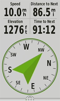
Dual GPS and GLONASS satellite reception enables our Rino series handhelds to accurately track and maintain your position — even in heavy cover, deep canyons or remote, off-the-grid locations. Each Rino also lets you share your waypoints, tracks, routes and geocaches wirelessly with other compatible Garmin handheld devices. A built-in barometric altimeter and 3-axis compass make it easy to get your bearings. And both Rino 750 and 755t support advanced mapping capabilities such as BirdsEye Satellite Imagery (1-year subscription included). In addition, Rino 755t comes with an 8-megapixel camera plus preloaded TOPO 100K mapping for an even more detailed view of the terrain.
Rino 755t has a built-in digital camera that makes it easy to capture locations, scenic views and memories of your travels. Each photo is automatically geotagged with coordinates, allowing you to navigate back to that exact spot in the future. Keep track of your photos and see their locations on a map using BaseCamp™ outdoor trip-planning software, which lets you view and organize maps, waypoints, routes and tracks. BaseCamp can also transfer satellite images to your device when paired with a BirdsEye Satellite Imagery subscription.

Both the Rino 750 and 755t handhelds come with a worldwide shaded-relief basemap. With our wide array of detailed topographic, marine and road maps available, it’s easy to install additional mapping products. Just use the unit’s microSD™ card slot to load the compatible mapping options you want. Or you can use our free Custom Maps software to transform paper and electronic maps into downloadable maps for your device.